
File:Oliver Paipoonge and Lakehead municipalities map.png

Original file (2,700 × 1,640 pixels, file size: 540 KB, MIME type: image/png)
Summary
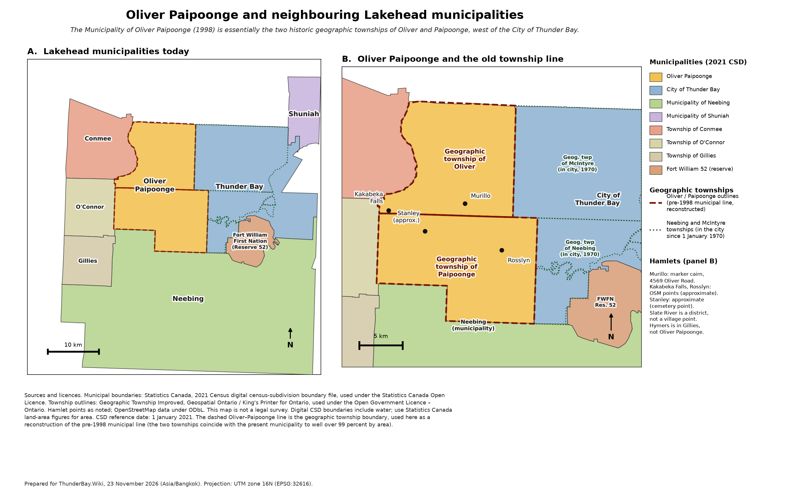
Two-panel map of the Municipality of Oliver Paipoonge and neighbouring Lakehead municipalities (City of Thunder Bay, Neebing, Shuniah, Conmee, O'Connor, Gillies, and Fort William 52), with the geographic township outlines of Oliver and Paipoonge shown as a reconstruction of the pre-1998 municipal line, and the geographic townships of Neebing and McIntyre shown inside the city (in the city since 1 January 1970).
Cartography prepared for ThunderBay.Wiki on 23 November 2026. Projection: UTM zone 16N (EPSG:32616). The map is not a legal survey. Digital census-subdivision boundaries include water; land areas should be taken from Statistics Canada figures. Census-subdivision reference date: 1 January 2021. Hamlet points: Murillo from the Ontario Heritage Foundation marker cairn at 4569 Oliver Road; Kakabeka Falls and Rosslyn from OpenStreetMap (approximate); Stanley is labelled approximate (Stanley Hill Cemetery point).
The source GeoJSON extracts and the drawing script are stored with the map files on the preparing machine; the PNG is the version used on the wiki.
Licensing
This file is a compiled map. The municipal boundaries are from the Statistics Canada 2021 Census digital census-subdivision boundary file, used under the Statistics Canada Open Licence. The geographic township outlines are from Geographic Township Improved, Geospatial Ontario / King's Printer for Ontario, used under the Open Government Licence – Ontario. Hamlet points from OpenStreetMap are used under the Open Database Licence (ODbL). Attribution for those sources is also printed on the image.
File history
Click on a date/time to view the file as it appeared at that time.
| Date/Time | Thumbnail | Dimensions | User | Comment | |
|---|---|---|---|---|---|
| current | 18:30, 22 November 2026 | | 2,700 × 1,640 (540 KB) | Admin (talk | contribs) | WikiBotBoss: Lakehead municipal boundaries, map, and why Oliver Paipoonge stayed separate (Michael, t318u) |
You cannot overwrite this file.
File usage
The following 4 pages use this file:
