
File:Thunder Bay ski hills vertical vs snow cover.png

Original file (2,250 × 1,125 pixels, file size: 293 KB, MIME type: image/png)
Summary
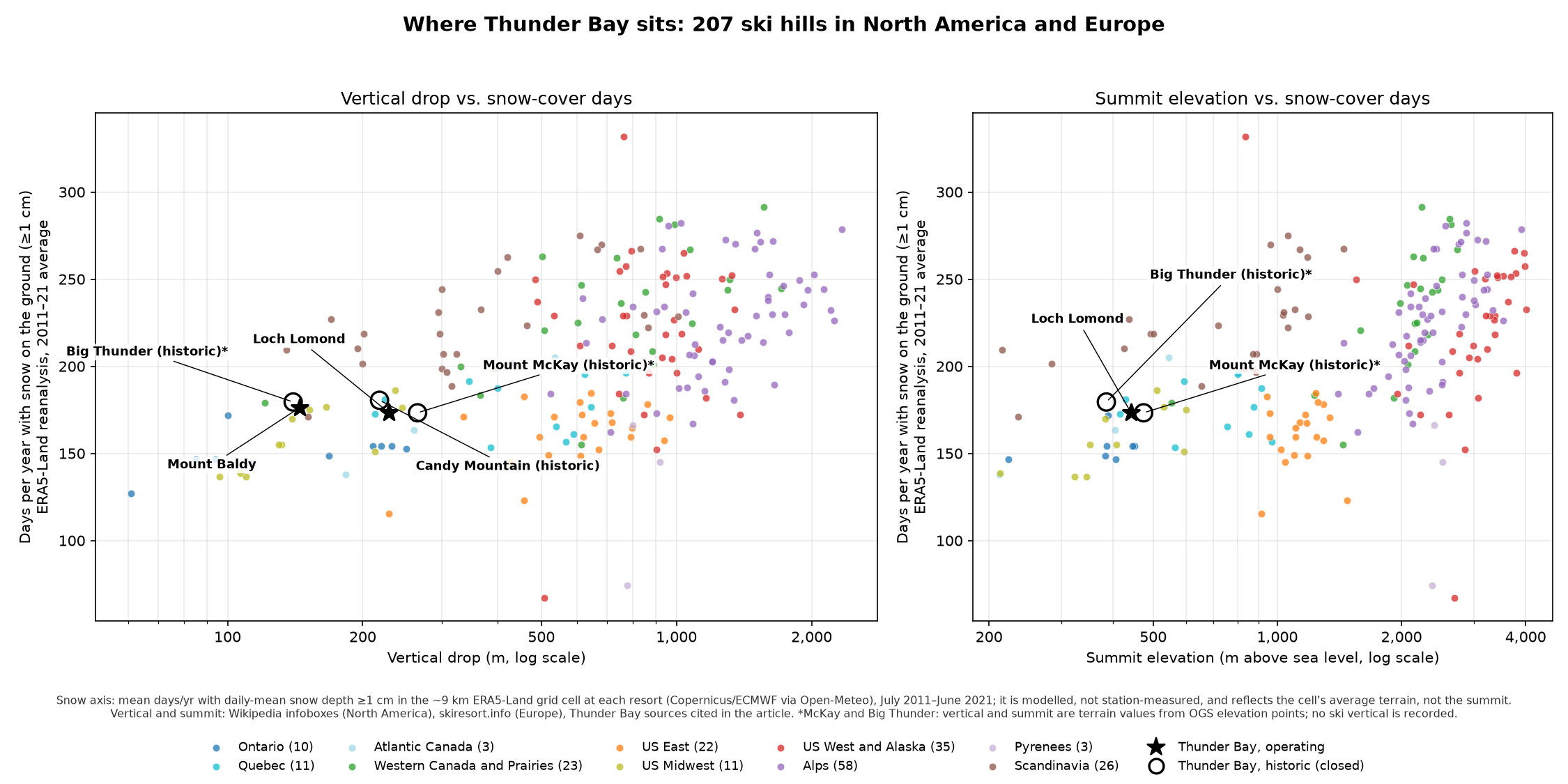
Scatterplot comparing 207 ski hills in North America and Europe by vertical drop (left panel) and summit elevation (right panel) against modelled snow-cover days per year. Thunder Bay's hills are highlighted: Loch Lomond and Mount Baldy (operating, stars) and Candy Mountain, Mount McKay and Big Thunder (closed, open circles). Made for History of skiing in Thunder Bay.
- Snow axis: the mean number of days per year with daily-mean snow depth of at least 1 cm, July 2011 to June 2021. Values come from the ERA5-Land reanalysis (Copernicus Climate Change Service / ECMWF; Muñoz-Sabater et al. 2021, doi:10.5194/essd-13-4349-2021) for the roughly 9 km grid cell containing each resort, retrieved through the Open-Meteo Historical Weather API (https://open-meteo.com/, data CC BY 4.0) on 25 October 2026. These are modelled values, not station measurements, and they represent the grid cell's average terrain rather than the summit.
- Vertical drop and summit elevation: for North America, the English Wikipedia infobox of each resort (the revision used is listed in the data file). For Europe, skiresort.info country lists (base and top elevation), accessed 25 October 2026. For Thunder Bay: Canadian Ski Hall of Fame (Loch Lomond, 229 m); Mount Baldy Ski Area (145 m); Skier 72 (Candy Mountain, 218 m). Mount McKay and Big Thunder have no recorded ski vertical, so their values are terrain relief from Ontario Geological Survey MRD 126 elevation points (via Macrostrat).
- Coordinates: Wikipedia/Wikidata (North America); OpenStreetMap Nominatim (Europe and Thunder Bay).
- Data file: ski_hills_vertical_vs_snow_cover.csv (one row per resort, with sources), kept with the article's research files. The data are also reproduced in a collapsible table in the article.
- Made with: Python matplotlib.
Licensing
Chart created 25 October 2026 for Michael Currie's thunderbay.wiki. Released under the Creative Commons Attribution-ShareAlike 4.0 licence (CC BY-SA 4.0). Underlying data: ERA5-Land (Copernicus licence, attribution required), Open-Meteo (CC BY 4.0), Wikipedia (CC BY-SA 4.0), skiresort.info (factual data, attributed).
File history
Click on a date/time to view the file as it appeared at that time.
| Date/Time | Thumbnail | Dimensions | User | Comment | |
|---|---|---|---|---|---|
| current | 19:20, 24 October 2026 | | 2,250 × 1,125 (293 KB) | Admin (talk | contribs) | Scatterplot of 207 ski hills: vertical drop and summit vs ERA5-Land snow-cover days, Thunder Bay highlighted |
You cannot overwrite this file.
File usage
The following page uses this file:
